The location of Warpsgrove House, mentioned several times in the Late Beating Up, is crucial to the understanding of the battle of Chalgrove. English Heritage Battlefield Register’s report has the following:
‘This establishes that the trees around the close, amongst which the Parliamentarians first dressed their lines and where they subsequently left their reserve, were by Warpsgrove House (where Warpsgrove Manor House Farm now stands).’
Warpsgrove Manor House, latterly Battlefield Manor, is 600 yards from Warpsgrove lane and the gap in the great hedge. The illogicality and absurdity of historians’ creating an interpretation of the Battle based on this data is beyond belief.
Warpsgrove House in 1643 was almost certainly a ruin. In the intervening years the site was scavenged for building material. Warpsgrove Manor Cottage (now Battlefield Manor) built in the early 18th century may have plundered stone from Warpsgrove House. Three stone cottages were built 100 yards from Warpsgrove House and probably had first pick of the House’s stone. Warpsgrove lane does a sharp left towards Hitchcock’s farm and on the corner directly ahead were the cottages. They were demolished in early in the 19th century yet some of this stone has survived in the stone walls close to The Lamb Inn, Mill Lane, Chalgrove.
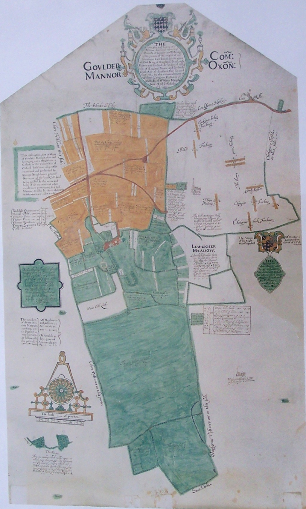
In 1612 William Webb was commissioned by Magdalen College to draw an estate map of Golder Manor (fig 1). (Note: On this map North is not the top) Webb’s map is drawn to the most accurate of scale with colour representing the field systems. Some of the trees, hedges and pastures depicted on the Golder map are still in evidence. The realisation that a peculiar hedge formation, possibly in days past used for penning sheep and drawn on Webb’s map corresponded in location to that found on an OS map. The ancient track on Golder Hill on which the troops descended is shown on Webb’s map. The track was still in use until the early thirties but was ploughed over and fell into disuse. Also depicted on Webb’s map is a thumbnail sketch of Warpsgrove House. The legend written under the sketch reads:
‘Warpsgrove House in tymes past a Parish Church’.
St Mary’s church records that St James’ church was located in the area of Warpsgrove House. In 1932 St Mary’s, Chalgrove took over the advowson of St James’ and in dedication inaugurated St James’ chapel in the North Aisle.
Warpsgrove House was in the parish of Warpsgrove and Webb’s map was commissioned by Magdalen College to show its holding of Golder Manor. Warpsgrove House is shown in white space on the map because ownership of such an important structure close to Golder Manor had to be established. There is barely a trace of Warpsgrove House left except for the odd pegged tile or a piece of dressed stone turned up by the plough. The sheep pen hedge detail was tangible and could be measured in relation to other markers such as a field corner. Ordnance Survey’s map concurred precisely with the location of the hedge detail and field corner which confirmed that William Webb’s map was not a work of art. Warpsgrove House’s possible site was in a featureless ploughed field which precluded using the technique of simply measuring and comparing to find its location. Webb’s fascination for accuracy may have included drawing the thumbnail sketch precisely located. Golder Manor to Easington church are fixed locations that still exist, therefore by drawing lines between these two points and the thumbnail sketch of Warpsgrove House a triangle is formed. Taking as a baseline the line between Golder Manor and Easington Church (“A”) and measuring the two angles “a” (angle of the line from Easington Church and Warpsgrove House and the base line) and “b” (angle of the line from Golder Manor and Warpsgrove House and the base line) allows for this triangle to be reproduced on any other maps regardless of their scale and orientation, including the modern OS maps (see: OS Map on Bing Maps). Therefore revealing the most likely location of Warpsgrove House.

When this exercise was carried out the location closely corresponded with the area where pegged tiles and dressed stone have been found. Victoria County History and South Oxfordshire Archaeological Group conducted a geophysical survey of the area defined by the calculation and found evidence of a structure. Lidar images of the given area reveal foundations of a building. The evidence is sufficient that Historic England have now extended the listed area relating to the battle of Chalgrove to include the site of the newly re-discovered site of Warpsgrove House.